Confusion in land re-survey has lessened for some
.. Increasing land for others .
Farmers’ questions were not answered in the re- survey. According to Webland / ROR, there are differences in land area and actual land area. Farmers are concerned about the decline in the land re-survey of their rightful ownership. According to the regulations, the land should first be demarcated and subdivided according to the area of land in the survey number. Then survey and show the boundaries to everyone. The survey stones should be laid after the appeals against them have been heard and resolved. But .. the superiors do not pay attention to this. Farmers are not fully aware of this process. Surveyors are incensed that this has reduced the area of land they have owned since the time of their grandparents.
Land source re-survey has become confusing. Farmers are not guaranteed anything. Land acreage is declining for many farmers. Farmers are concerned that survey and revenue staff say the acreage of land they have experienced has decreased over the past 50, 60 years. The pass books, the land in the documents, have nothing to do with what is said in the survey. Differences in measurements also lead to conflicts between farmers. Survey and Revenue staff in the village secretariats are unable to answer the questions of the farmers. Criticisms have been leveled that superiors do not care about solving field-level problems. More problems are emerging near landfills, joint ventures, and government-sponsored land acquisition farms. Land re-survey is being carried out under the YSR Jagannath Permanent Right-Land Protection Scheme.
Representatives of ‘Today’ examined the situation in the villages where the re-survey had been completed and in the villages where the measurements had reached the final stage. Although months have passed since the completion of the re-survey in 51 villages in the first installment … old survey numbers and old areas are still visible in Adangal online. Farmers did not receive new graduate passbooks. It is unknown at this time what he will do after leaving the post. Although the re-survey was completed, the boundary stones were not planted in most places. Staff say farmers should stick to it.
Decreased land is not shown
Prakasam District Markapuram Mandal Shivarampuram resident P. Srinivas had 2.4 acres of land. After re-survey it was shown as 1.97 acres. Although the stone was cast that the farm had been reduced to ten cents, the land had not been adjusted to that extent. The farmers of the adjoining farms did not agree to change the ridges in accordance with the documents given by the authorities.
Banks do not lend
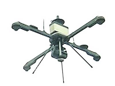
Anakapalli District Natavaram Mandal Chollangipalem 54.78 acres of land was surveyed for two years. Land parcel map (LPM) numbers were generated by drone surveying 24.81 acres of fallow land, 2.30 acres of fallow land and 17.87 acres of Poramboku land belonging to 60 farmers. Some lands were lost during the survey while others were added up. Kalla Ramana, a farmer, complained that 6 months after the completion of the survey, he was still not given his passbooks and the banks did not give him loans as he did not have the details of 1B and Adangal online. Registrations are not going on as these village LPM numbers are not linked to the secretariat.
* Atmakuru mandal, Nellore district, during the re-survey in Nuvurupadu, it was decided that there was additional land and it was added to the neighbors. The farmers disagreed and wanted to re-survey.
Farmers’ awareness of differences
Eluru District Jangareddygudem Revenue Division Akkampeta After the re-survey, the land area has decreased for some and increased for others. The cost of a cent of land here is Rs. ‘In Vishwanath’s Kandriga Agraharam, donka roads were attacked .. Farmers are in trouble. In the re-survey, the road should be calculated and the boundary stones should be laid, ‘said M. Krishna from Yedlapadu zone of Palnadu district.
Why did the problem that was not in the 2016 survey come up now?
‘I did the survey in 2016 with a government surveyor. Then the problem did not come. My land is within my jurisdiction. It has come down to 13 cents in the re-survey, ”said Srinivasa Rao, a resident of Rantapalla in Sattanapalli zone. The survey was completed in Jaggayyapeta zone Sher Mohammadpet in Vijayawada division, Potlapalem in port zone, Marribandam in Noojeedu division and Merakagoodem in Gudivada division. Farmers say there are still problems with the demarcation of boundaries in these villages.
Unknowingly planted boundary stones
‘We have 16 acres of land in Survey No. 26 in the hilly Jagarlamudi range. Decreased by 10 cents during the re-survey. Let’s say we deduct 6 cents in the tens of thousands that belong to us. If there is Ennespee canal land on one side, ten cents of the land is mixed with boundary stones. He said that there was no government land and that we would reduce it on our own land but he did not do so. This is changing everyone’s ridges. They are planted 10 feet away from the embankment, ”said Rambabu of Pratipada zone in Guntur district.
 We are taking measurements on their lands- Shamprasad, US Collector, Palnadu
We measure in the presence of farmers in the identified villages for re- survey and determine the acreage. We explain to farmers where problems come from. Boundary stones are being planted in farmers’ fields under the Employment Guarantee Scheme. For some the land area is increasing.
 Re-survey in accordance with the directions – Parthasarathy, Deputy Inspector of Survey, Palnadu
State Government is conducting the re-survey following the directions issued. We are educating the farmers at every step. Photographs by drones and rovers identify land status quo.
Problems intensify on assignment lands
When assigned lands are given to the poor, the government should order the conversion of land into agricultural land. However .. DKT rails were given to the poor without any change. It is on record as government land as the conversion will not take place. These cases are mostly in the case of lands to Pond Porambo. The Supreme Court has directed that water resources sites should not be assigned. With this the re-survey shows these as pond poramboku.
Differences in pumps
Differences are coming in reassurance pumps. Although one agrees … the other disagrees. Although the parents may have written to the extent of the boundaries, the boundary details are not in the documents. During the re-survey he was caught writing down the roadside space for himself. The staff is putting it together because there are no papers.
In the case of joint wells …
Wells cannot be subdivided according to the Survey Boundaries Act. Disputes are coming up over the right to space in these wells. In those days there were joint wells to meet the needs. Not now. Farmers far away from the well site did not get a share. There is no technically right claim. The well will have no client. The procedures on what to do at such times are not clear.
 There is no share in the ground well
– Haribabu, farmer, Yedlapada zone, Palnadu district
I have 2.25 acres of land inherited from my grandparents in Viswanadhu Kandriga Agraharam. I lost some of my land which was in three parts in the re-survey was not measured properly. The side yard has a joint 4cm well. Survey staff said I had no share in it.
 Why survey if we speak for ourselves?
– Sambashivarao, Rantapalla, Sattenapalli Mandal, Palnadu District
If measurement problems arise during the re-survey … the survey staff says that you should all talk and solve them together. Officials should confirm, but why re-survey if the farmers themselves are talking? I lost 2-3 cents per acre of land.
 How to reduce 29 cents?
– Tirupathaya, Konda Jagarlamudi, Guntur District
We have 92 cents of land in Survey No. 27-3 on the hill Jagarlamudi. A re-survey shows that what we have in our experience is 63 cents. If you ask me this, they will tell you how much land you are cultivating. The ridges have not been held for 3 decades. However, there are 63 cents. If there are 4 sub-divisions in the survey number, how can it be reduced in one and why is there 92 cents in the records? There is no answer from the authorities.
Land details are not available In the
Anakapalli district, the district registrar Srinivasa Rao mentioned that the registration could not take place and the re-surveyed village said that the details of the land were not available and hence the registration could not be done. NIC told them that they would solve the problem.
Many problems

New issues are emerging in the re- survey. More problems are coming up in cases registered under inheritance without documents. Registering beyond the survey number and area in ROR / Webland. Due to lack of documents, the actual acreage is not clear. Staff say this makes them unable to do anything on their own while reducing their acreage. Land acquisition for Nagarjunasagar project canal at NSP canal Poramboku in Marripalem, Yedlapada zone, Guntur district. As a result, the boundaries of many lands changed, some reduced in size and some increased. The solution to this problem is to say that the NESP Canal is within their purview. Officials say farmers who have lost land will have to pay compensation and seize the surplus land.


